GreenValley
Products
GVI aims to provide versatile LiDAR hardware systems to accurately map any 3D environment. Through the use of SLAM (simultaneous localization and mapping), our Handheld and Mobile systems can rapidly scan both indoor and outdoor environments without the need for GPS. This ability allows foresters, archaeologists, civil engineers, surveyors, and more to build robust datasets without prep or complex post-processing software.
  • X3C-H UNIT ONLYproduct template
    LiAir X3C-H

    Scan Rate: 1,920,000 points/s (Triple Return)

    Weight: 1.12kg (with camera)

    FOV: 360° (Horizontal) ×40.3° (Vertical)

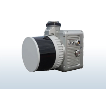
    New integrated design style

    Built-in high-resolution mapping camera

    Providing higher performance

    Convenient operation for power-line inspection

    Topographic surveying, agricultural and forest monitoring, etc

    READ MORE
  • lidar 360 product template
    LIDAR 360
    Launched in 2013, LiDAR360 is a professional processing platform for massive point cloud data Ldeveloped by GreenValley International. The platform employs over ten different types of international leading point cloud algorithms, artificial intelligence, and machine learning to promote the use of LiDAR across the industry and solve users' application problems while unlocking the full potential of their point cloud data. The software can analyze and process massive point cloud dat...
    READ MORE